SAMUEL VAN VALKENBURG, 1890-1976
HENRY J. WARMAN
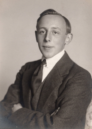
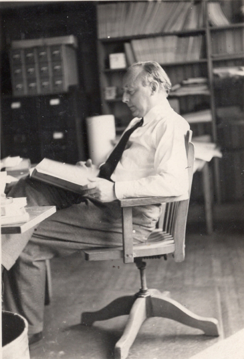
The passing of Dr. Samuel Van Valkenburg in April, 1976, brought to a close not only the distinguished career of a great national and international geographer but also that of a confidant advisor to many and a warm friend to a host of students and colleagues. Born in Leeuwarden, Holland, eighty-six years ago he was introduced early in life to the international, commercial part which the Netherlands has played on the world scene for centuries. His superb education prepared him well for his subsequent full-life role. After high school he studied geography under specialists at the University of Utrecht in 1913, at the University of Zurich in 1914 and again from 1916 to 1918, and at the University of Berlin in 1915 and 1916. He received his doctorate at Zurich. Post-doctoral work was pursued at the Universities of Neuchatel and Lausanne. In 1971 an honor-ary doctor of laws degree was conferred upon him by Clark University. He had served the University as Visiting Professor (1927-29), Associate Professor (1932-37, after four years at Wayne University), Professor (1937), and, starting in 1946, as Director of the Graduate School of Geography.
His ability to speak several languages (Ger-man, French, Dutch, and English) and to understand many more including Italian, Spanish, and East Indian tongues was drawn upon frequently at International Geographical Congresses and conferences. It was quite common to hear such requests as this over the loud speaker, “Will Dr. Van Valkenburg please come to the registration desk? We need your assistance in helping several delegates to register.” When prospective Ph. D. students who were struggling with the foreign language requirements complained to Dr. Van he would say, “Go tell your problems to a bell hop in Switzerland; he speaks four languages and understands two more”.
The multiple-language capabilities possessed by Dr. Van were matched by the many fields of geography in which he was expert. This expertise is evident in his writings and in the subjects he taught. Early research and writings were on preglacial landsurfaces of the Swiss Alps and on the place of geomorphology in the tropics evidence of his knowledge of geology. physical geography and especially physiography. The climatology course, offered every year at Clark, exposed all graduate students (even terrifying a few neophytes) to his knowl-edge of atmospheric as well as surface creations and their interplaying and behavioral patterns. Interest in man’s economies and land use stud-ies was indicated early by his articles on Indonesia, particularly on Java, where he served as the Governmental Geographer of the Royal Topographic Survey of the then Dutch East Indies.
A constant admonition given by Dr. Van to all students was “You must know that earth in the field as well as in the classroom.” His frequent reminder, sometimes a directive, to both colleagues and writers of theses and dissertations was, “Go and take a look at it.” Students were prodded into field work although most had experienced the Fall Field Camp and already had spent a day with Dr. Van in the field. Col-leagues often were reminded that research funds for field work were available. “Who is planning to tap it this summer?” “Who goes on leave next?” were common topics at staff meetings. Dr. Van recognized the fact that many graduate students already had fine college training and also had read much of the literature. Therefore, a Graduate School faculty must have the added dimension of considerable field work.
Extending the frontiers of geographic knowledge and the reassessment of work previously done were integral parts of the curriculum under Dr. Van’s tutelage. Epitomizing this are his originals and revisions of his regional book on Europe and his Elements of Political Geog raphy. His desire to initiate a World Land Use Survey brought geographers together from many lands. He realized the undertaking was monumental but the research started in the field was needed and does continue. The resultant training of researchers and their writings are contributions to our present-day fund of information about the world’s lands and peoples.
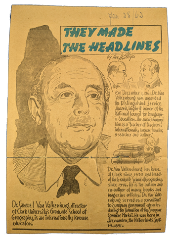
Dr. Van Valkenburg served as chairman of the International Geographical Union Land Use Commission, was vice-president of the Association of American Geographers, presi-dent of the New England-St. Lawrence Valley Geographical Association, and president of the Worcester Economic Club. His membership on the Executive Board of the National Council for Geographic Education was an exciting time for him. He had been concerned for some time about the role geography was playing in the public and private schools of his adopted country and wanted to do something about it. In the initial stages of the High School Geography project he was a zealous advocate. His efforts along these lines were recognized in 1961 when the Distinguished Service Award, the highest honor of the National Council for Geographic Education, was bestowed upon him.
On one occasion at a National Council session a public school teacher asked him, “Dr. Van Valkenburg, what method of teaching do you use?” Dr. Van wrinkled his forehead, raised
his bushy eyebrows, his eyes widened in surprise, and then he replied, “Method? Method? 1 don’t have any method. I just teach!” But many of us who were his students, colleagues, or associated with him in other ways know he had a very effective method. Most will recall the carefully researched and constructed maps drawn on the blackboards, with different colored chalk in the late afternoon of the previous day or the early morning hours of the lecture day. There also was a profusion of maps hanging from wall racks, or thumb-tacked to portable blackboards. These were not stage settings but integral parts of what was to be taught and, hopefully, to be learned. Students will recall how each color on the maps was used to develop an element or even an idea, how the scale was utilized, how the legend carefully was used to open the door to learning and, finally, how a big “X” was drawn. over the lecture map indicating the end of that discourse. New students were cautioned by “old-timers” not to leave the classroom before they had made a copy of what was essentially a manuscript map. Later, in examinations, there usually would be a desperate need for recalling map details when questions like the following were asked, “Compare or contrast the land use and problems along the east and west banks of the Rhine River from the Gorge to its mouth.” Such a question might be in the Europe course. One like this could appear in Political Geography, “Discuss the political geography changes in the Middle East since 1940 using at least two maps to assist you.” The human, physical, political, economic geographic depth of Dr. Van was exemplified in each lecture. He expected some of the same to come through in his students.
The attention of students naturally was held during the map discourses. It was sharpened decidedly, however, upon occasions when the ten-foot long fishing pole (used as a pointer) was thrust within six inches of a student’s nose and a question asked of him. Considerable conditioning, aided by a great deal of study, prevented mental panic when the quivering tip of the fish pole emphasized this classroom technique. Or should one call it “method”? If method is designed to teach the content, moti-vate learning, and finally interest the student in’ the subject then Dr. Van had a very effective method.
“If you don’t understand come and see me,” was a frequent statement. “I’m in my office at 7 am!” Many students and colleagues took advantage of this invitation. The actual presence of Dr. Van in office was indicated by the smell of smoke from his Dutch cigar. He was a good listener and did something about the situations whether they be securing a place to live, a different place, library problems, ethnic situations, shortage of money, a new position, or a change in a present one. This concern for people at a face-to-face, ground level was evidenced inter-nationally as well. Clark University and Dr. Van Valkenburg’s office became a “port-of-call” for geographers world-wide. Invariably, the students benefitted for the travellers were asked to give short talks or lectures and be guests at teas arranged in the Libbey Library. Subsequently, some graduates were welcomed abroad by these visiting professors. The inter-national aspect was inaugurated and is still maintained.
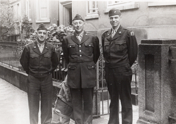
During World War II Dr. Van Valkenburg was a consultant to the Quartermaster General and a member of his Advisory Board. He also was a consultant in military intelligence at the Office of Strategic Services. His writings, but especially his first hand knowledge gleaned on his travels throughout all of Europe, North Africa, East and South East Asia, Australia, the Caribbean, and North America, made him quite indispensable. When geographers were needed in strategic areas he drew upon his colleagues in other universities and their students as well as his own to fill the assignments. His leadership, along with others, in this previously little-used geography service to the nation filled a gap but also did much to advance geography to the professional level which it holds today in government circles.
Finally, it would be quite inappropriate to close this memorial without commenting upon the pleasant gatherings in the Van Valkenburg home and the graciousness of Dr. Van’s devoted wife. Graduate students and professors from nearby and distant regions will recall fondly the teas and dinners served in truly European style in the family home. They also will remember the times when the phone rang in the middle of an afternoon conference or staff meeting in Dr. Van’s office and a voice would say, “Sammy, the tea is ready.” Dr. Van would excuse himself and leave after a day which had begun at 6:30 a. m. and extended to tea time, 4 p. m. It seemed to many like a well-regulated life. It was, but it was a well-lived life, too. Much was crowded into a day, but very much came out of each day for everyone who was involved.
Surely, Dr. Van Valkenburg was a geographer who loved his world and the people in it. Professional associates will remember him as a most competent, international, national, and local geography expert. Colleagues and students will remember him as a devoted teacher, dedicated to his subject, a zealot for speaking, writing, and research, and as an advisor in professional and personal matters. The writer remembers him for all the foregoing attributes but mainly because he was a very close friend and travel companion. Even though the association during the years was professional the writer always could say as he now writes this after a close acquaintanceship of thirty-five years. “I liked my boss.”
All who knew Dr. Van will miss him. While his writings have lasting value, his greatest leg-acy is the many students who have had the good fortune to come under his direction. They will carry on for him by demonstrating his love for teaching and learning, his zeal for excellence, and a real concern for development of their special interests. In addition, they will keep their office doors open for conference, and for encouraging and advising potential devotees of the geography discipline. Dr. Van Valkenburg’s life and works are the inspiration to do these things.
Dr. Warman is Professor of Geography, Emeritus, at Clark University in Worcester, МА 01610.
ANNALS OF THE ASSOCIATION OF AMERICAN GEOGRAPHERS Vol. 67, No. 2, June 1977 by the Association of American Geographers. Printed in U.S.A.


